An Amazing Time at Marvins Marvelous Mechanical Museum!

We had seen an article about “Marvin’s Marvelous Mechanical Museum” in a “Things to Do” book. It sounded interesting, but we never got around to visiting it.
Well, we finally did, and the panel of experts all agree, it was worth the time!

It is not a far drive up to Farmington Hills from Ann Arbor, so we left about noon, stopped for some lunch and got to the museum about 2 pm.
Marvins Marvelous Mechanical Museum
I was surprised, there was no entry fee. I expected to pay a few bucks just to get inside.
When you open the door and walk it, it is a smorgasbord of sights and sounds for the senses to feed on!

I suggest you use one of the picture links to view the entire photo album so you can see what I mean!

Towards the end of the visit a nice person was standing between some machines just sort of watching. I realized this was Marvin in person. I said “Hello” and he immediately struck up a conversation. He wanted to show us the “Tic-Tac-Toe” playing chicken, which I think is one of his favorites from the literature and advertising I have seen.

Marvins Marvelous Mechanical Museum

Marvins favorite Arcade item?


Marvins Marvelous Mechanical Museum

At the end the chicken will reward you with a nice post card

Marvins Marvelous Mechanical Museum

I can only still imagine what this did… I did not try a quarter to see it in action.

Marvins Marvelous Mechanical Museum

Some things are just better left to the imagination.

We spent several hours roaming around the place. It is not huge, but it is packed, and I do mean packed, with interesting articles from the rafters to the floor, and every nook and cranny in between.

If you are in the Detroit area, and Farmington Hills with a few extra hours take time to stop by and see this place!

Until the final quarter is played,

George


A day to remember to forget.

August 1, 2010 at 6:30 am was the start of the Rock ‘n’ Roll Chicago Half Marathon. This was my first Rock ‘n’ Roll race, and the course was flat. I thought it would be a good time to try and break the two hour mark, so I signed up earlier in the year to make sure I got in before it sold out.

A hotel room was booked, vacation days signed up for, groceries purchased, suitcases packed, and finally the car was loaded up. First stop, after the requisite quick coffee drive by, was the Health and Fitness Expo at McCormick Place in Chicago.

I picked up my bib and SWAG bag and then wandered around the hall for awhile.

The Chicago Rock 'n' Roll Half Marathon bib.

Brooks apparently is a large sponsor and had all sorts of attractions… see the Jesus Lizard and racing pictures. There were plenty of samples available, so I carbo loaded right at the show with energy bars from the major manufacturers. After seeing everything we wanted to see we took off for the next stop. The Chicago Art Institute.

First though we needed some real food, so walked a couple blocks, went down the stairs, and under the bridge to the Billy Goat Tavern.. home of the Cheezeborger. Hopefully some of you will remember the Saturday Night Live skits (Beluschi) that were created from a visit to this restaurant. “Cheezeborger – Cheezeborger – Cheezborger! No fries! Cheeps! No Pepsi. . . Coke!” Well it was an interesting place, the food passable,(having the double cheese burger of course! – one of use having a double double…) glad we went to see, may or may not ever go back. There are just to many places to eat on the trips we make to “double up” to often unless it is something we rate “outstanding”. (Maggianos Italian).

Bellies full, we walked back to the art museum where we spent hours wandering the halls looking at paintings, lots of paintings. Old painting, new paintings, great paintings and those that left you scratching your head. Finally we headed to the hotel for the night, stopping first at… Maggianos for some pasta.

Saturday we visited the Chicago Botanic Gardens. Started in 1972 (?) as a small greenhouse it has grown into a major garden. A very nice place, and certainly glad we went. We were not sure beforehand what it would be, or how long to plan on being there… thinking we may be done in a hour or two and then go do something else. As it ended up we spent the entire day there. We finished the day with the tram ride that circles the gardens. The driver/tour guide was either a) a hoot, or b) annoying…. done in a very folksy style it was more comedy than informational. For me anyway it was cute at first but would have liked a little more substance, history, facts, etc to be presented.

A early dinner at McCormick and Schmicks and then off to the hotel. We had to get up at 4 am to get ready and make the drive to downtown Chicago to be ready for a 6:30 am start time. We are early risers, but 4 is early!

We made it in good time, the traffic was very light, and got into a parking garage with no problems. A couple block walk to the venue and we were ready for race time.

On our way, behind a white picket fence was the celebrity pen. A couple people who I did not know were there stretching and being covered by cameras. Still don’t know who they were, but one was “The Bachelor – Jake” one was… aw heck who cares anyway, we are here for a race not a show.

The course opened about 6 am, and it filled quickly. There were 29 corrals, one of the picture’s in the album shows them stretching far into the distance. Based on earlier half marathon times I submitted I was in corral #8. At 6:30 the horn sounded and the first group was off. Each corral started about a minute apart, so it was about 10 minutes into the race when I crossed the start line. The first couple miles went according to plan. The only issue being the Garmin was showing me as running a lot further than the course was marked. Much later, after the race and back home, I loaded the gps track into Google Earth and zoomed in on the course. It appears the tall building played havoc with the Garmin since the track was all over the place even doubling back on itself, no wonder it showed me running 14 plus miles. This also then affected the pace it was showing… not that I use it for much of anything normally.

I passed by the photography team just before the six mile mark, things were still going pretty good at that point, but shortly after that it started to be a struggle.

Excuse List for Chicago Rock ‘n’ Roll Half Marathon:

    a) I walked miles the day before at the Botanic Gardens

    b) I was on my feet for hours, and walked miles on Friday at the Art Institute.

    c) It was hot, reaching 80 degrees by the end of the race.

    d) I dropped my headband in the porta pot before the race and sweat kept running down into my eyes.

    e) It has been so hot recently my weekly mileage dropped way off, into the teens, instead of in the 30-40 mile range.

    f) The sun was in my eyes

    g) I didn’t have any coffee before the race

    h) My right shoe was loose

    i) My left show was tight and had a hot spot

    j) My heart rate monitor strap was loose and kept sliding down around my belly.

    k) something else

    l) whine

    m) whine

So I ended up running the slowest half I have ever run, by 15 minutes… ouch.

I don’t want to, but I always add the statistics… so here goes.

The Chicago Rock 'n' Roll Half Marathon results.

The six mile time was still pretty close at 1:04 which would be 2:08 plus another 11 for the final 1.1 miles, so 2:20 isn’t far off…. but then I guess 2:28 isn’t that much more than 2:20… very flawed runner logic…

I have to say, this outfit seems pretty efficient. They had the results posted in hours, with 18,000 plus finishers. Some other races I have run it takes days, for only several hundred runners! They also set up a nice finishers certificate which you can download and print out. I think saving it as a pdf is good enough for me.
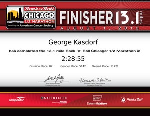
The Chicago Rock 'n'  Roll Half Marathon finishers certificate.

To make the aching legs feel a little bit better they have a fairly decent finishers medal also.
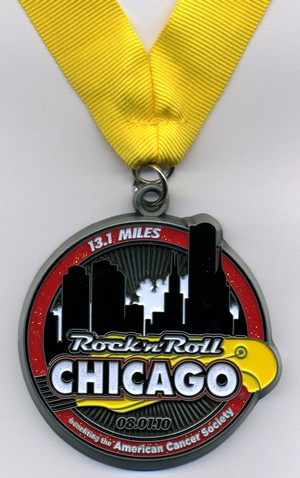
The Chicago Rock 'n'  Roll Half Marathon finishers medal.

Still, it was fun and I enjoyed it, once I cooled off a little bit. After getting the finisher medal and some water we headed back to the hotel where I took an ice bath to help the legs on the drive back home. Glad I did since the drive ended up over six hours. There was construction on I-94 that held us up quite a while until we stopped for some supper and took the back roads for awhile until we were past the mess.

Finally back home, unpacked, and went to bed… and that is the end of the 2010 Chicago Rock ‘n’ Roll Half Marathon.

Pictures of the expo and race!

Until the sun sets over Lake Michigan in Chicago . . . .

George

Places to run – part X

It is always fun to go for a hike/run/walk, whatever you do outdoors for exercise or enjoyment. I recently was in Georgia and did a fun trail in the Georgia Forest system, Unicoi State Park. There are several trails but the one I did, since I was staying in Helen Georgia, was the Helen to Unicoi trail. It was also a good chance to try out the GeoSetter software with some pictures I took. The trail is very nice, from the hotel to the lodge and back was just a shade over six miles. With the gain/loss of elevation, and the temperatures in the 90’s it made for a pretty good work out. Glad I took a bottle of water along with the camera! (Which did make for a bit of a load to carry the entire time.) I have a hand held water bottle (Nathan) **Runners Tip! While the Nathan comes with a bottle with a valve on the top, I find it just as easy to use standard water bottles from the store. No clean up afterwards, you can also (properly recycle) dispose of the bottle if you no longer need it and just stick the carrier somewhere and go “hands free” then.** I also have a SPI belt and travel with small zip lock bags… I can put the camera in a zip lock bag and stuff it in the SPI belt when I am done with photos. The bag is necessary, at least for me, to keep sweat from destroying the camera. You might be surprised at how NON-waterproof digital cameras are… another story for another day.

One thing that is in the album I will mention here since it sounds pretty cool. Georgia State Parks offer a number of incentives to attract people to visit the parks. One is for hiking, running, etc. The
Georgia Canyon Climbers Club. Sign up, give ’em ten bucks, visit four parks and do the specified trail at each one and get the Tee Shirt! Looks like fun. I need to map out where the four parks are in relationship to where I go and see if it is something I could do. Unfortunately I have limited time and Georgia is big enough that getting to the site in time to do the trail may not be feasible.

Hey, try this link to see the trail in Google Maps! It seems to work okay. Click on the link on the left and the picture should show up in the location along the route it was taken.

Until the final State Park is visited,
George

A historical weekend in Mexico

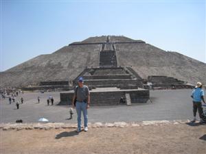
I spent a weekend in Santiago de Queretaro and had the chance to do some sight seeing. A group went to the Teotihuacan region just Northeast of Mexico City. This area has a huge city of ruins, including the third largest pyramid in the world. “The Pyramid of the Sun”. While it is not as tall now as it originally was it is still very impressive!

The Pyramid of the Sun in the background.

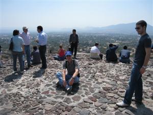
A climb to the top presents a challenge to many, especially those not used exercising, or to an altitude of 7,300 feet, but if time is taken most people make it there, and it is worth the climb. A great view of the entire complex and surrounding neighborhood can be had.

They say there is great energy coming from the structure, so you can “recharge” at the top.

We spent the day walking and climbing and taking lots of pictures!

After climbing to the top of the Pyramid of the Sun sitting down to

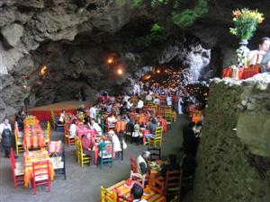
After walking about 10 miles, and getting somewhat sunburned, we finished our tour and went for some lunch. Nearby the ruins is “La Gruta” restaurant. It is located in a grotto, or cave, and while open to the outside, the temperature was guite pleasant, almost cool.

After a morning walking through the Pyramid's a beer in a cool cave was refreshing!

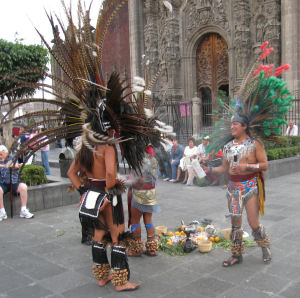
We then headed into Mexico City, and the Historical Central District. The area contains many old churches of magnificent size and construction. There was also a large market area where everyone was attempting to be unique to attract buyers. I particularly liked the indians and their costumes. Hopefully the long feathers are not from any endangered species!

After a morning walking through the Pyramid's a beer in a cool cave was refreshing!

Finally a long drive back to the hotel, the warm shower and a soft bed felt pretty good!

George

Creating a Custom POI File for Magellan GPS – Part 2

In the prior post in this series I went through creating the actual POI file using ITN Converter. In this post I am going to show you how to make that file actually useful for something… like finding locations with your GPS!

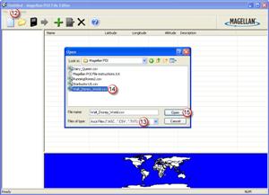
Open the Magellan POI Editor. Then open the .CSV file you previously created. As shown in (13) select .CSV since that is what you created last time (or should have). Select the file you created in (14), and then click on Open (15).

You did download the Magelan POI Editor from the earlier post…. correct? *Sigh*
Here it is again….

Download Magellan POI Editor – UPDATE 12/14/2015 this pointed to a link that was no longer valid so I removed it.

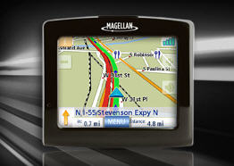
Magellan Maestro 3250 GPS Unit

Small and portable it can be used in the car or stuck in a pocket for pedistrian use – like walking around Disney World! (Batteries are supposed to be good for 3 hours or so.)

Okay, now that you downloaded the POI Editor, and know where it is at, go ahead and open the Magellan POI Editor. Then open the .CSV file you previously created. As shown in (13) select file type of .CSV since that is what you created last time (or should have). Select the file you created in (14), and then click on Open (15).


The Magellan POI File Editor - Open File dialog box.

Use the dialog box to browse to the .CSV file you previously created.


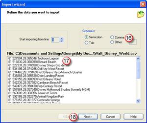
The software will automatically open the Import Wizard when it sees you open a .CSV file.

The software will automatically open the Import Wizard when it sees you open a .CSV file. Unless you have a “header” line that you saved (it the view window it would probably look different than the other data shown.) You should leave the “Start Importing from line = 1, set to 1. Some downloaded files have several rows of information about where the file came from, what’s included, who made it, etc. so you may need to change this to line 2, 3, or ?

Continue reading

Attempting to Create a Custom POI file – Part 1

The family goes down south to Disney World in Orlando every couple of years (well twice now….) we always have a good time there seeing all the sites and attractions. Also everytime I say “I wonder why there is no GPS Point Of Interest file available for download into a GPS unit”. This seems like a “natural” to me. Especially for persons having portable GPS units that want to get to an attraction in the shortest route possible from inside or outside of the park. So, I searched the internet and came up with one “Disney World POI” file… but it only has about six entries for the gates of the different theme parks… not so useful for what I want!

I decided to create my own file. No problem. Open the Magellan POI program and enter in the information that is required.

Oh, you don’t have Magellan POI File Editor software on your PC/Mac. Man, you are soooo out of luck.

It is supposed to be on the CD that came with your GPS. Being extremely lazy I did not even try to locate that CD… I just Googled until I found a link someone posted. Maybe I should be nice and add a link to let you download it from here….. we’ll see….

Magellan POI Editor UPDATE 12/14/2015 The link to the POI Editor no longer works so I have removed it. Try searching for this. Things are a lot easier now than when I originally posted the link. Not to mention the version I had posted is long out of date!


Magellan Maestro 3250 GPS Unit

Small and portable it can be used in the car or stuck in a pocket for pedestrian use – like walking around Disney World! (Batteries are supposed to be good for 3 hours or so.)

Seems simple enough, there are only about three things: Latitude, Longitude and Name for each POI. Oh, what is that information for each of those? Where do you get it? Hmmm… maybe not quite so easy after all. Open Google Earth, pan around until you find the location, zoom in to make sure it is right, copy the info from the screen into the Magellan POI program…. sort of time consuming. Maybe not such a great idea after all, but it seems like there should be a better way to do this.

A search found a web site forum with some hints, and a reference to another web site where you can do latitude and longitude lookups using an address, name, etc. Check this out –>
UPDATE 12/14/2015 This appears to no longer be working so I removed the link but you can copy and paste to try it. “itouchmap.com/latlong.html”. One thing it does others may not, reverse lookups… if you have a latitude and longitude plug them in and see where in the world it is at. Might be good for doing a “cross reference” check on points you have.

But, this is still a rather slow, copy and paste operation. Find the location, copy the info (a piece at at time) paste it into your file, add Name/Description and go to the next place. If you have a lot of points be prepared to spend some serious mousing time. So… there has to be a better way. Google to the rescue again! An extended search for: POI +file +create and some other terms and come up with a lot of nothing…. wait what is this one…. ITN Converter…. download it, install (cool it doesn’t “really” need to install, it is an executable that runs on it’s own. Even from a USB memory stick.)

So… does it work or not?

Continue reading