A day to remember to forget.

August 1, 2010 at 6:30 am was the start of the Rock ‘n’ Roll Chicago Half Marathon. This was my first Rock ‘n’ Roll race, and the course was flat. I thought it would be a good time to try and break the two hour mark, so I signed up earlier in the year to make sure I got in before it sold out.

A hotel room was booked, vacation days signed up for, groceries purchased, suitcases packed, and finally the car was loaded up. First stop, after the requisite quick coffee drive by, was the Health and Fitness Expo at McCormick Place in Chicago.

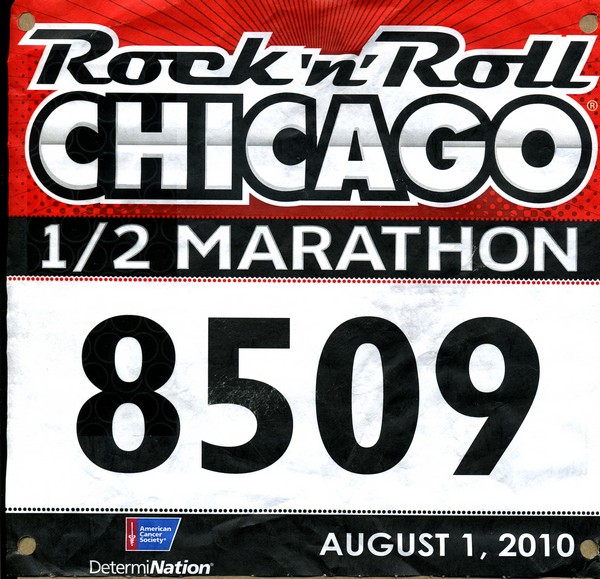
I picked up my bib and SWAG bag and then wandered around the hall for awhile.

The Chicago Rock 'n' Roll Half Marathon bib.

Brooks apparently is a large sponsor and had all sorts of attractions… see the Jesus Lizard and racing pictures. There were plenty of samples available, so I carbo loaded right at the show with energy bars from the major manufacturers. After seeing everything we wanted to see we took off for the next stop. The Chicago Art Institute.

First though we needed some real food, so walked a couple blocks, went down the stairs, and under the bridge to the Billy Goat Tavern.. home of the Cheezeborger. Hopefully some of you will remember the Saturday Night Live skits (Beluschi) that were created from a visit to this restaurant. “Cheezeborger – Cheezeborger – Cheezborger! No fries! Cheeps! No Pepsi. . . Coke!” Well it was an interesting place, the food passable,(having the double cheese burger of course! – one of use having a double double…) glad we went to see, may or may not ever go back. There are just to many places to eat on the trips we make to “double up” to often unless it is something we rate “outstanding”. (Maggianos Italian).

Bellies full, we walked back to the art museum where we spent hours wandering the halls looking at paintings, lots of paintings. Old painting, new paintings, great paintings and those that left you scratching your head. Finally we headed to the hotel for the night, stopping first at… Maggianos for some pasta.

Saturday we visited the Chicago Botanic Gardens. Started in 1972 (?) as a small greenhouse it has grown into a major garden. A very nice place, and certainly glad we went. We were not sure beforehand what it would be, or how long to plan on being there… thinking we may be done in a hour or two and then go do something else. As it ended up we spent the entire day there. We finished the day with the tram ride that circles the gardens. The driver/tour guide was either a) a hoot, or b) annoying…. done in a very folksy style it was more comedy than informational. For me anyway it was cute at first but would have liked a little more substance, history, facts, etc to be presented.

A early dinner at McCormick and Schmicks and then off to the hotel. We had to get up at 4 am to get ready and make the drive to downtown Chicago to be ready for a 6:30 am start time. We are early risers, but 4 is early!

We made it in good time, the traffic was very light, and got into a parking garage with no problems. A couple block walk to the venue and we were ready for race time.

On our way, behind a white picket fence was the celebrity pen. A couple people who I did not know were there stretching and being covered by cameras. Still don’t know who they were, but one was “The Bachelor – Jake” one was… aw heck who cares anyway, we are here for a race not a show.

The course opened about 6 am, and it filled quickly. There were 29 corrals, one of the picture’s in the album shows them stretching far into the distance. Based on earlier half marathon times I submitted I was in corral #8. At 6:30 the horn sounded and the first group was off. Each corral started about a minute apart, so it was about 10 minutes into the race when I crossed the start line. The first couple miles went according to plan. The only issue being the Garmin was showing me as running a lot further than the course was marked. Much later, after the race and back home, I loaded the gps track into Google Earth and zoomed in on the course. It appears the tall building played havoc with the Garmin since the track was all over the place even doubling back on itself, no wonder it showed me running 14 plus miles. This also then affected the pace it was showing… not that I use it for much of anything normally.

I passed by the photography team just before the six mile mark, things were still going pretty good at that point, but shortly after that it started to be a struggle.

Excuse List for Chicago Rock ‘n’ Roll Half Marathon:

    a) I walked miles the day before at the Botanic Gardens

    b) I was on my feet for hours, and walked miles on Friday at the Art Institute.

    c) It was hot, reaching 80 degrees by the end of the race.

    d) I dropped my headband in the porta pot before the race and sweat kept running down into my eyes.

    e) It has been so hot recently my weekly mileage dropped way off, into the teens, instead of in the 30-40 mile range.

    f) The sun was in my eyes

    g) I didn’t have any coffee before the race

    h) My right shoe was loose

    i) My left show was tight and had a hot spot

    j) My heart rate monitor strap was loose and kept sliding down around my belly.

    k) something else

    l) whine

    m) whine

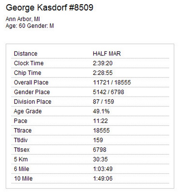
So I ended up running the slowest half I have ever run, by 15 minutes… ouch.

I don’t want to, but I always add the statistics… so here goes.

The Chicago Rock 'n' Roll Half Marathon results.

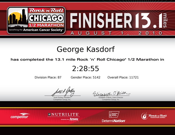
The six mile time was still pretty close at 1:04 which would be 2:08 plus another 11 for the final 1.1 miles, so 2:20 isn’t far off…. but then I guess 2:28 isn’t that much more than 2:20… very flawed runner logic…

I have to say, this outfit seems pretty efficient. They had the results posted in hours, with 18,000 plus finishers. Some other races I have run it takes days, for only several hundred runners! They also set up a nice finishers certificate which you can download and print out. I think saving it as a pdf is good enough for me.

The Chicago Rock 'n'  Roll Half Marathon finishers certificate.

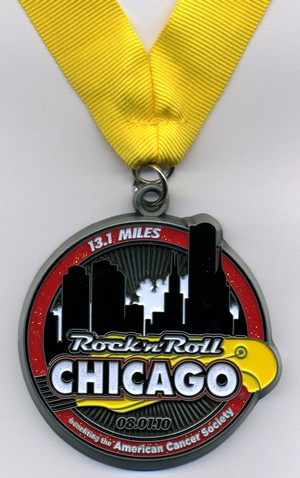
To make the aching legs feel a little bit better they have a fairly decent finishers medal also.

The Chicago Rock 'n'  Roll Half Marathon finishers medal.

Still, it was fun and I enjoyed it, once I cooled off a little bit. After getting the finisher medal and some water we headed back to the hotel where I took an ice bath to help the legs on the drive back home. Glad I did since the drive ended up over six hours. There was construction on I-94 that held us up quite a while until we stopped for some supper and took the back roads for awhile until we were past the mess.

Finally back home, unpacked, and went to bed… and that is the end of the 2010 Chicago Rock ‘n’ Roll Half Marathon.

Pictures of the expo and race!

Until the sun sets over Lake Michigan in Chicago . . . .

George

Places to run – part X

It is always fun to go for a hike/run/walk, whatever you do outdoors for exercise or enjoyment. I recently was in Georgia and did a fun trail in the Georgia Forest system, Unicoi State Park. There are several trails but the one I did, since I was staying in Helen Georgia, was the Helen to Unicoi trail. It was also a good chance to try out the GeoSetter software with some pictures I took. The trail is very nice, from the hotel to the lodge and back was just a shade over six miles. With the gain/loss of elevation, and the temperatures in the 90’s it made for a pretty good work out. Glad I took a bottle of water along with the camera! (Which did make for a bit of a load to carry the entire time.) I have a hand held water bottle (Nathan) **Runners Tip! While the Nathan comes with a bottle with a valve on the top, I find it just as easy to use standard water bottles from the store. No clean up afterwards, you can also (properly recycle) dispose of the bottle if you no longer need it and just stick the carrier somewhere and go “hands free” then.** I also have a SPI belt and travel with small zip lock bags… I can put the camera in a zip lock bag and stuff it in the SPI belt when I am done with photos. The bag is necessary, at least for me, to keep sweat from destroying the camera. You might be surprised at how NON-waterproof digital cameras are… another story for another day.

One thing that is in the album I will mention here since it sounds pretty cool. Georgia State Parks offer a number of incentives to attract people to visit the parks. One is for hiking, running, etc. The
Georgia Canyon Climbers Club. Sign up, give ’em ten bucks, visit four parks and do the specified trail at each one and get the Tee Shirt! Looks like fun. I need to map out where the four parks are in relationship to where I go and see if it is something I could do. Unfortunately I have limited time and Georgia is big enough that getting to the site in time to do the trail may not be feasible.

Hey, try this link to see the trail in Google Maps! It seems to work okay. Click on the link on the left and the picture should show up in the location along the route it was taken.

Until the final State Park is visited,
George

Runs you don’t think about… but should

When I go to different locations I enjoy finding a new place to run. I also enjoy taking photos along the way, especially if I am in a park, or somewhere unusual.

But sometimes our backyards we don’t think about… but should. I go out the back door several times a week and run in a great place, Matthaei Botanical Gardens in Ann Arbor MI. In several years of running there I never took a camera, or even thought about it.

I have been playing with some new software to do Geo-Tagging of my photos, and was looking for some pictures which I could use. To do this I needed a GPX track recorded to match the camera time against, not having anything like this I decided I needed to go take some photos while wearing my Garmin 305….. so I did. I put on the watch, grabbed the camera and headed out the back door to the park.

There are several outcomes from doing this. The easiest is to create the photo album with the tagged photos using Jalbum. When viewing this album (as well as most of my others) you can click on the word “See Map” below the photos and it will open Google Maps and take you to where the photo was taken. Pretty cool. I have been doing this for some time, but using Picassa and Google Earth to do the tagging. This works great, but is far to time consuming to tag each photo with an individual location so I usually resorted to grouping photos in areas. This method allows every photo to have its own location code. The software also lets you reposition the photo on the map to correct for any inaccuracies in the GPS coordinates that were saved. These are typically fairly close, but not always close enough to suit me. It also allows you to create a “track” or “route” which can then be displayed on Google Earth with the pictures on it in their proper locations.
I need to do a little more experimenting on that function yet before I release it. I did some experimenting way back when, but haven’t done much with this project lately.

Until I get a track laid down I guess this will have to suffice. Update July 25, 2010… I “got the track laid down” and am sharing it here.

As to the photos of the park itself, I actually ended up with a lot more photos than I thought I would, and actually ran a few places I do not normally go, just to see what was there that might be “photogenic”. I hope you enjoy seeing “My Running Park”.

Until the final bridge is crossed,
George

Solstice Run 2010 – Running without the horses…

The second annual (for me) Solstice Run in Northville Michigan has come and gone.
The Northville Solstice Run has several races, 5K, 10K, and new in 2010 a 10 Mile race. They all feature a starting lap around the Northville Downs horse race track. Giddy Up!

Victory at Northville Downs.

Photos were taken of the event by the faithful support team.

The official results for the race. Not what I would have hoped, or even expected, off from last year by several minutes. (2009 was 57:57)
Bringing Home the Roses.

There are trotters, pacers, thoroughbreds, quarter horses, plow horses and nags.
Guess it was the day for the plow horses….,

George

Shamrocks & Shenanigans 2010

March 14, 2010 is not Saint Patrick’s day, but not all that many people can go run a race on a Wednesday… unless they make it a National Holiday or something so everyone gets the day off! Hey, I ‘ll vote for that. Anyway, the race was held on Sunday, the weather was damp and cool but not all that bad. Some mist in the air but actual rain held off so everyone stayed pretty dry. Only one or two trash bag raincoats were spotted… mine stayed in the car.

Sponsored by Conor O’Neills bar downtown, the race goes right past it several times.

Conor O'Neill's bar.

The race did not go as planned… you know I wanted to get under about 16 minutes… yeah… right. Really I was aiming for about 26 plus a few seconds since my previous best is 26:32. I started pretty well at the end of the pack and did not realize it would be so hard or take so long to clear the crowd. A lesson learned. They also had two lanes merging into one at the starting mats, so that backed things up, and then the walkers also merged from the cross street at the same time. A bit of chaos for awhile.  Overall though, no excuses. Even once I cleared traffic I did not get back on pace. Just plain old sluggish lately. Definately a lack of miles, and have not done any speed stuff since last summer.  Hey I am not that great, but I think even for us mid-packers it makes a difference.  Starting to get miles back up this week with warm weather I can run out the front door without having to drive somewhere… makes it easier. Plus the route here has more hills than Geddes Park where I do most of the winter runs.

Some stats for the race:

a) 5K, or 3.1 miles.

b) ran at a 9:28 pace (29:24 total time)

c) finished 612 out of 1597 overall, so finished in the top 39% of all runners.

d) finished 8 out of 16 in my age group. So about 50% finished ahead of me…. and 50% behind me.

e) had a great time, which was the real race goal!

This was the third time I have run the Shamrocks & Shenanigans 5K in downtown Ann Arbor. It is hosted by Running Fit stores and sponsored by Connor O’Neills bar.

Until the final Leprechaun is caught for his gold,

George

Uploading Custom POI files to a Garmin GPS Unit.

In the first part of this two part series I wrote about creating a new POI file using ITN Converter and saving it so you may upload it into your GPS unit.

So, are you ready to proceed?

If you did not install the Garmin POI loader software when you got your unit, go and download it, then install it on your PC.
https://www8.garmin.com/products/poiloader/

Use the link to download. This page also mentions “Proximity Alerts” which you will need to set later when you are uploading your files to the GPS unit.

Uploading a custom POI file to a Garmin.GPS.

Now that you have the “POI Loader” installed you are ready to go. Get your GPS unit, plug it into your computer using a USB cable. When it is attached turn the GPS on. After a short time the the Garmin screen should show something like the following picture.
Uploading a custom POI file to a Garmin.GPS.

Now open the Garmin POI Loader software using your new desktop icon.
Uploading a custom POI file to a Garmin.GPS.

The software should open up, read what it has to say and then click “Next”.
Uploading a custom POI file to a Garmin.GPS.

The next screen asks where you want to save your POI file to. Until you learn more about this, leave the default “Garmin Device” radio button selected. If is does not happen to be selected, do so, then click “Next”.
Uploading a custom POI file to a Garmin.GPS.

If you have the Garmin plugged in properly, and it is turned on, the program should automatically find your device. You can click on the button (15) but should not have to do so. Either way, make sure it shows in the window before you proceed. Once it does, click “Next” (17).
Uploading a custom POI file to a Garmin.GPS.

In the next window you can clear the old POI’s from the unit (perhaps you have some you no longer want. If you are just adding new POI files, or overwriting your existing ones, then just leave “Linstall new customer POI’s onto your device” radio button selected. Then click on “Next”.
Uploading a custom POI file to a Garmin.GPS.

The next window requires some minor decisions to be made by you. Where is/are the POI files located at on your system. You do remember where you saved them from the first post when we created them… browse to that folder. (18)
Uploading a custom POI file to a Garmin.GPS.

TIP: If you begin making multiple POI files create separate folders for the “Current” and “Old” files.

TIP: If you begin making multiple POI files, or editing them and like to save the old versions as I do, then create separate folders for the “Current” and “Old” files. When you start to upload you will find it makes things much easier to select the files you want to use.
Pick your units of measure that you use. (19) and finally select whether you want the software to automatically upload everything, or if you want to do it manually. Select “Manual”! (20) I am pretty sure you won’t like the defaults on the automatic setting. Finally, click on “Next”. (21)
Uploading a custom POI file to a Garmin.GPS.

Once you click “Next” it will start preparing the files to upload. For every file it finds in the directory you selected it will ask what you wish to do with that file. (22) (This is why only having the current files in the directory is handy, you don’t have to skip all the files you do not want loaded.)
You can “Ignore the file” and go to the next one in the directory you selected. You can decide if you want “proximity alerts” for the file or not. (23) Basically these notify you when you are in range of any of the specific points contained in the file you are opening at the time. The “Alert when speed is greater than the Alert Speed” setting could be used to warn you to slow down when you are nearing your intended destination so you do not go past it, or maybe if you have “speed traps” programmed in it will just pop up a warning when you are in the vicinity of the programed locations. In that case a red box pops up on the GPS warning you that you are exceeding the speed you have selected. I like the “Alert whenever you get close to a point, and go with the default quarter mile (1320 feet). You might also like a half mile or some other distance. If so just enter it here and make sure you select the associated radio button. Once you have made your choices, click on “Next”. (24)
Uploading a custom POI file to a Garmin.GPS.

Once you have selected and configured the final file in the directory the software automatically goes to work. It converts the files to the correct format and loads them all into the GPS unit. This only takes a few seconds normally. Unless maybe you have some extremely large files. I have a total of almost 15,000 points I load and it goes quite rapidly. Once the “Congratulations” screen pops up you are done! Click “Finish (25) and then detach your GPS from the USB cable and go for a drive!
Uploading a custom POI file to a Garmin.GPS.

Now that you have added all your favorite POI’s you need to know how to find them on the unit! Since I had been using a Magellan unit for some time prior to getting the Garmin it took a few tries to get to them the first time. Once you do it though it is easy enough in the future.
When the unit starts up, you get the main screen. Click on “Where To?”.
Uploading a custom POI file to a Garmin.GPS.

On the next screen go to “Extras”
Uploading a custom POI file to a Garmin.GPS.

On the next screen go to “Custom POI’s” (Go figure…)
Uploading a custom POI file to a Garmin.GPS.

Finally if you have multiple Custom POI’s you will be given a choice of them. Here is why adding the number to the beginning of the file name helps to put the frequently used files at the top of the list.
Uploading a custom POI file to a Garmin.GPS.

Now that you have the file loaded you can pick the location you want to navigate to from the list.
Uploading a custom POI file to a Garmin.GPS.

Verify this is the location you want to navigate to and hit “GO”!
Uploading a custom POI file to a Garmin.GPS.

And as soon as it calculates everything you are on your way!
Uploading a custom POI file to a<br /> Garmin.GPS.

Until the final way point is added,
George