Creating Editable GPS Files from a .MGLN format file.

In a previous post I stressed making sure you saved your original .CSV file which you imported into your Magellan GPS since it creates a .MGLN format file. At the time I did not know a way to edit that file in the future. A little research found it can be done. If you have an Magellan “.MGLN” file in your unit here is how you can save it to allow editing with some of the tools I have previously recommended.

Open the Magellan POI File Editor.

Find the .mgln file you want to edit. You did save it. . . right? If not, all is not lost. If you plug your Magellan unit into a computer using the USB cord, it should link up. Use Windows Explorer (or a better method like “Power Desk”) to find the unit. Work your way through the directory structure until you find the .MGLN file you want. Copy this file back to your PC.

Viewing files on a Magellan Maestro 3250 GPS Unit

Now open the .MGLN file you previously saved or the one you just retrieved from the Magellan GPS.

Example:

  • (1) find the directory it is stored in
  • (2) highlight the .MGLN file
  • (3) Click on “Open”.Magellan Maestro 3250 GPS Unit

    When it open’s it you should see the list of all the Categories and their POI’s. Pick the Category (5) you want to save so all the POI’s appear in the right pane. (6)

    Magellan Maestro 3250 GPS Unit

    Click on the first entry (7)

    Magellan Maestro 3250 GPS Unit

    Go to the last entry in the list, or the last items you want to export, hold down the Ctrl + Shift key, left click on the entry. (8) All the POI’s between the first and last selected one’s should now be highlighted.


    Magellan Maestro 3250 GPS Unit

    Right click anywhere in the window (Do not left click or you select only the one POI and have to start over!), then click on Copy (9) (Or if you know your shortcuts you can simply use “Ctrl + C” to copy these.


    Magellan Maestro 3250 GPS Unit

    Open Excel, (10) (actually I have found I greatly prefer to use Notepad – or any plain text editor – for this) “Paste” the information from the clipboard. (12) (Or use “Ctrl + V”)
    Continue reading

  • Creating a Custom POI File for Magellan GPS – Part 2

    In the prior post in this series I went through creating the actual POI file using ITN Converter. In this post I am going to show you how to make that file actually useful for something… like finding locations with your GPS!

    Open the Magellan POI Editor. Then open the .CSV file you previously created. As shown in (13) select .CSV since that is what you created last time (or should have). Select the file you created in (14), and then click on Open (15).

    You did download the Magelan POI Editor from the earlier post…. correct? *Sigh*
    Here it is again….

    Download Magellan POI Editor – UPDATE 12/14/2015 this pointed to a link that was no longer valid so I removed it.

    Magellan Maestro 3250 GPS Unit

    Small and portable it can be used in the car or stuck in a pocket for pedistrian use – like walking around Disney World! (Batteries are supposed to be good for 3 hours or so.)

    Okay, now that you downloaded the POI Editor, and know where it is at, go ahead and open the Magellan POI Editor. Then open the .CSV file you previously created. As shown in (13) select file type of .CSV since that is what you created last time (or should have). Select the file you created in (14), and then click on Open (15).


    The Magellan POI File Editor - Open File dialog box.

    Use the dialog box to browse to the .CSV file you previously created.


    The software will automatically open the Import Wizard when it sees you open a .CSV file.

    The software will automatically open the Import Wizard when it sees you open a .CSV file. Unless you have a “header” line that you saved (it the view window it would probably look different than the other data shown.) You should leave the “Start Importing from line = 1, set to 1. Some downloaded files have several rows of information about where the file came from, what’s included, who made it, etc. so you may need to change this to line 2, 3, or ?

    Continue reading

    Attempting to Create a Custom POI file – Part 1

    The family goes down south to Disney World in Orlando every couple of years (well twice now….) we always have a good time there seeing all the sites and attractions. Also everytime I say “I wonder why there is no GPS Point Of Interest file available for download into a GPS unit”. This seems like a “natural” to me. Especially for persons having portable GPS units that want to get to an attraction in the shortest route possible from inside or outside of the park. So, I searched the internet and came up with one “Disney World POI” file… but it only has about six entries for the gates of the different theme parks… not so useful for what I want!

    I decided to create my own file. No problem. Open the Magellan POI program and enter in the information that is required.

    Oh, you don’t have Magellan POI File Editor software on your PC/Mac. Man, you are soooo out of luck.

    It is supposed to be on the CD that came with your GPS. Being extremely lazy I did not even try to locate that CD… I just Googled until I found a link someone posted. Maybe I should be nice and add a link to let you download it from here….. we’ll see….

    Magellan POI Editor UPDATE 12/14/2015 The link to the POI Editor no longer works so I have removed it. Try searching for this. Things are a lot easier now than when I originally posted the link. Not to mention the version I had posted is long out of date!


    Magellan Maestro 3250 GPS Unit

    Small and portable it can be used in the car or stuck in a pocket for pedestrian use – like walking around Disney World! (Batteries are supposed to be good for 3 hours or so.)

    Seems simple enough, there are only about three things: Latitude, Longitude and Name for each POI. Oh, what is that information for each of those? Where do you get it? Hmmm… maybe not quite so easy after all. Open Google Earth, pan around until you find the location, zoom in to make sure it is right, copy the info from the screen into the Magellan POI program…. sort of time consuming. Maybe not such a great idea after all, but it seems like there should be a better way to do this.

    A search found a web site forum with some hints, and a reference to another web site where you can do latitude and longitude lookups using an address, name, etc. Check this out –>
    UPDATE 12/14/2015 This appears to no longer be working so I removed the link but you can copy and paste to try it. “itouchmap.com/latlong.html”. One thing it does others may not, reverse lookups… if you have a latitude and longitude plug them in and see where in the world it is at. Might be good for doing a “cross reference” check on points you have.

    But, this is still a rather slow, copy and paste operation. Find the location, copy the info (a piece at at time) paste it into your file, add Name/Description and go to the next place. If you have a lot of points be prepared to spend some serious mousing time. So… there has to be a better way. Google to the rescue again! An extended search for: POI +file +create and some other terms and come up with a lot of nothing…. wait what is this one…. ITN Converter…. download it, install (cool it doesn’t “really” need to install, it is an executable that runs on it’s own. Even from a USB memory stick.)

    So… does it work or not?

    Continue reading

    I was lost, but now I’ve found my way.

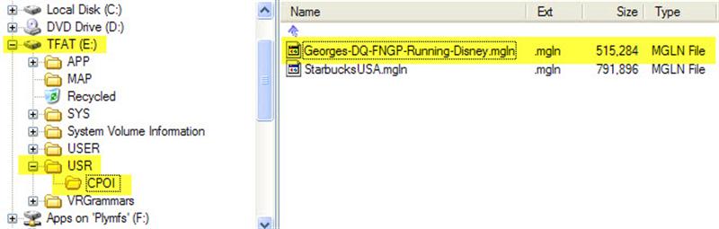
    I have been spending the last couple of days playing around with the Magellan GPS software. A long time ago . . you know way back in time, like two years ago… I created a custom POI file for all the sites at the company for which I work. Now when I travel to them I can just select a “Custom POI” file and go! Also helps getting there from hotels, airports, etc.

    Then last weekend we went for a drive to see the fall foliage, and had a hunger for a Starbucks coffee. Even with 9,000 or so of them in the US it isn’t always easy to find one. When we got back home I did an internet search and found a POI file for all the Starbucks in the US! Perfect, just what I wanted, a complete list to upload into the GPS!

    BUT…., isn’t there always a “but” . . . there is a problem in getting them from the standard downloadable file format into the Magellan. Downloading a .CSV file works okay, and the Magellan POI program imports them okay. The first time I did this, I immediately imported it into the Magellan GPS and it worked like a charm. Then I saw the crazy descriptions for each location in the unit and decided I would clean them up. Since many of the descriptive names are longer (I think the Magellan limits it to about 16 spaces.) it would truncate the description in the unit and look strange and of no real help anyway. So I opened the .CSV file in Excel and changed all the names to “Starbucks”, nice and simple. Reimported into the Magellan POI software, saved everything and closed down for the night.

    The next day getting ready to upload to the GPS unit, I opened my file again, and crap . . . it only had about four locations in it, when it should have had thousands! What the heck, well I must have saved it wrong, or maybe with the wrong name, or I opened the wrong file and so on. So I recreated the file again, carefully saving it as an ASCII .CSV file in a known location. Everything looks great now. So closed things down until I got the GPS unit to upload to later. Okay, now I am again ready to update the unit, so I open the Magellan POI software, open the carefully saved .MGLN file (special Magellan format they create within the software) and . . . . CRAP!! It is missing all the data except the same stinking four locations. Okay, go through the whole process again, check the locations before and after the ones that show up… they look fine. No strange characters, no extra commas (comma delimited .CSV file) everything is perfect, so save the file, reopen it and look at the beautiful work that I did . . . . CRAP! Gone again. Now being a fast learner and all I went through this process about 8 times with the exact same results everytime. (Insanity = doing the same thing you have always done and expecting different results. ) Finally gave up on it and went back to reading a book. Couldn’t get this out of my mind though…. so kept thinking about it… what is different this time than before…. first time I saved it, and then immediately uploaded into the Garmin… but why should that make a difference? Oh, the other thing I did was “clean up” all the long descriptive file names. . . . hmmm. . . . If every name is now just “Starbucks” and originally they were “Starbucks at the corner of 5th and 27th Street in Madison Wiscon….” what is the difference… okay now ALL the descriptions are exactly the same…. hmmm…. Back to Excel, import the .CSV file, delete all the descriptions, put in “Starbucks 000001” and then drag down the column changing each description to “Starbucks 00001”, “Starbucks 00002”, “Starbuck 00003” and so on….. now save it in Excel. Open it in Magellan POI editor, save it, exit and reopen the MGLN file again. Hot Dang… there they all are!


    Magellan POI Software

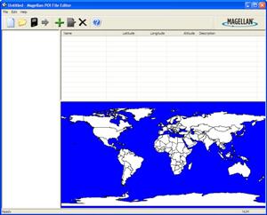
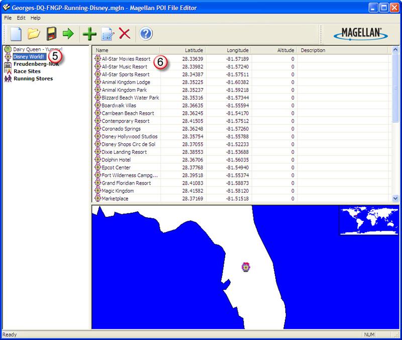
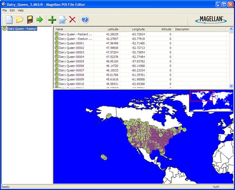
    The interface for the Magellan POI software is pretty simplistic. When you load up a file it shows all the locations… and if you have reversed the latitude and longitude it shows up real quick! What a DQ in the middle of the South Atlantic! Must be one they opened on an cruise ship going to Antartica.

    The other thing I realized as I went through all of this, when I tried the GPS with the original downloaded points it did not find some that I thought for sure should be there… like right down the street from the house. Again I assumed the file would be correct, and there must be some reason they were not included, like it is inside of a store, not a stand alone building or it is to new to be included, and so on. What I now realize is that all the descriptive names that ended up being truncated leaving the exact same description were skipped from the file. Maybe it is thinking that location is already in the file so is attempting to be helpful by not saving duplicates….. so a lot of locations ended up with similar descriptions and therefore not included.

    With this great success I looked up the next most important, or actually maybe even THE most important locations to find on a trip…. ALL the Dairy Queen’s in the USA! I now have a file loaded into the GPS so we can immediately locate a DQ for a quick sugar fix whenever we need it on the road! WOOT! Instant ice cream locations, all 5,332 of them!

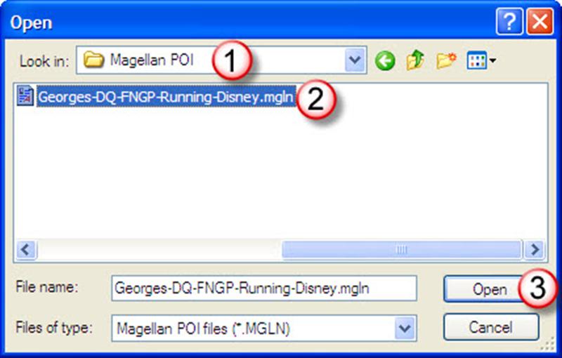
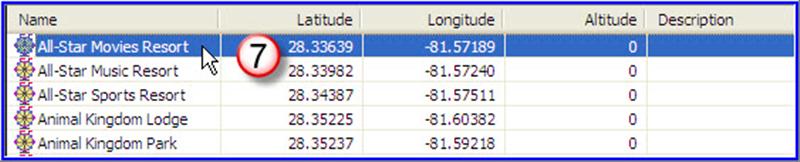
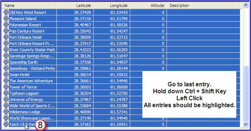
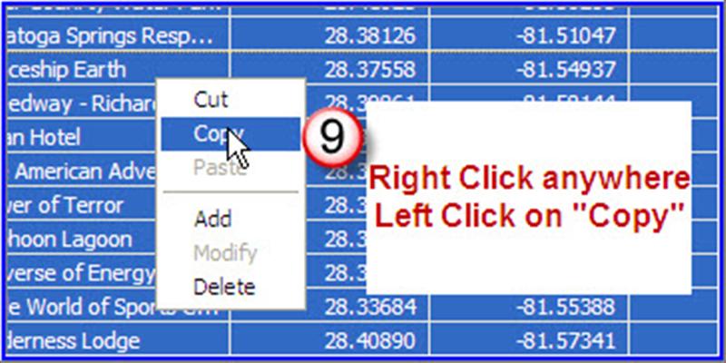
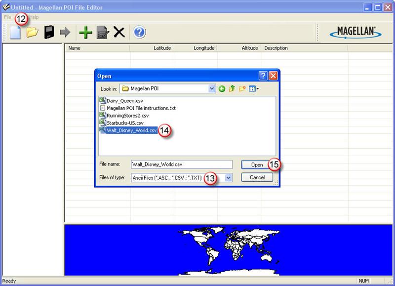
    Next project: Programming all the Parks, lodges and major attraction at Disney World in Orlando… the only “ready made” file I found only has the theme park locations in it. I want the Disney resorts, lodges and other things like International Village and the “Shops”, along with nearby attractions of interest… and the hotel we like there.

    Until the final satellite burns up on reentry,

    George

    Software and Running = Part 2

    In which I continue the monologue on equipment and software I use to track exercise efforts.

    Software for recording Running and Races. The first software I got for tracking workouts and races was Runners Studio. I have been using it for about nine months at this point. I really like the layout of the software, it is easy to navigate and has a nice visual appeal. One of my favorite features is the “upcoming race” calendar/listing.  You can enter races that you want to run or are thinking about running into the software and it lists them all in a page view. The view includes customizable columns so you can add/remove what you want to see, or rearrange the order of the columns. The entries may also be sorted by different columns such as date of race, have you registered yet, length of race, etc. The view also shows the number of days remaining until race day, a very handy visual to use for planning. It also quickly reminds you of how many days there may be between races, so if you need to set priorities it is easy to do.

    A short list of my favorite features:

    • Import data from Garmin Training Center. Much easier than entering all the lap data manually, also includes elevation, heart rate, etc.
    • Track run data from GPS using Google Earth with a click of the mouse.
    • Track shoe useage to see how many miles you put on them.
    • Goals you can set for about any combination of miles, time, pace, weight, etc
    • Mega-Goals which can be set to see how far you run in total, can you make it around the world? I’m just working on getting from California to New York…..
    • Upcoming races which I mentioned.
    • Race history which lists all the races you have entered, your goal and the results.

    I could list everything the program does, but it would be easier for you to visit his web page, read what he has to say, and then download the software and try it out!

    The program is constantly being updated, and the author seems receptive to adding new features that are requested as he has done for my requests several times. There is still a “wish list” I have for him, but it is getting closer to my ideal program with every revision!

    Software and Running = Part 1

    When I started exercising more the first thing I bought was a fairly simple pedometer. It is a Omron Model HJ-720ITC which has the ability to export data into it’s own software tracking program. The first entry was August 1, 2007.

    As of today I have more than 1,450 miles and 2,600,000 steps recorded in the last 14 months. Note that the miles is probably not all that accurate since the stride length used to calculate distance was set up for a walking pace, and my running stride is somewhat longer, so the distance shown is correspondingly shorter. I use this mostly as a reference number so am not disturbed with the inaccuracy knowing in my mind that I have run far more than the pedometer indicates.

    +++++
    Click on the picture to see a larger image.
    Pocket Pedometer with PC software HJ-720ITC
    Omron’s most technologically advanced pedometer, model HJ-720ITC, now includes Omron Health Management Software to help you track days, weeks, months and years of exercise. Simply connect the pedometer with its USB connection to your PC to begin tracking your health today. The pedometer measures steps, aerobic steps (10 minutes or more of continuous movement), calories and distance. Your path to better health is just steps away.

    +++++

    I still wear the pedometer when I exercise whether it is running, walking, treadmill, etc. I do not wear it all day which a lot of people do, but I am more interested in seeing what efforts I expend outside of normal activity.

    The plus’es to the pedometer are that it resets automatically every day at midnight so you do not have to remember to reset it to capture the daily steps. Another plus is it seems very accurate in picking up steps. It does not seem overly sensitive as to where it is kept or worn while in use.

    The negatives to the pedometer. It resets itself every night, and only every night. It cannot be manually reset. If I transport the pedometer it will begin counting steps before I begin an exercise period and it cannot be zeroed before I begin. Sometimes this can add a significant amount of steps. To some degree they can be ignored since they typically are not “aerobic” steps, and I mainly track only aerobic activity. But it does mess up totals. Another negative is that it is very sensitive, and will pick up steps wherever it is located…. including in a suitcase or even sitting on a car seat. This is what adds “unearned” steps. Basically the strengths are also the undesired traits.

    The plus’es of the ability to download all the activity into the software outweigh the negatives, at least for my use.

    If anyone is aware of  a pedometer on the market that can be manually reset and also downloads daily data to a PC please let me know! Until I find one the Omron Pedometer gets the Team Toe-Jammer seal of approval.

    Until the final foot fall falls over the land,

    George